

NOCO Trail: Redline and Alternate Updates
Segment 1 - Hourglass Trail - Comanche Peak Wilderness
Segment 1 Redline Reroute & Alternate Route Updates
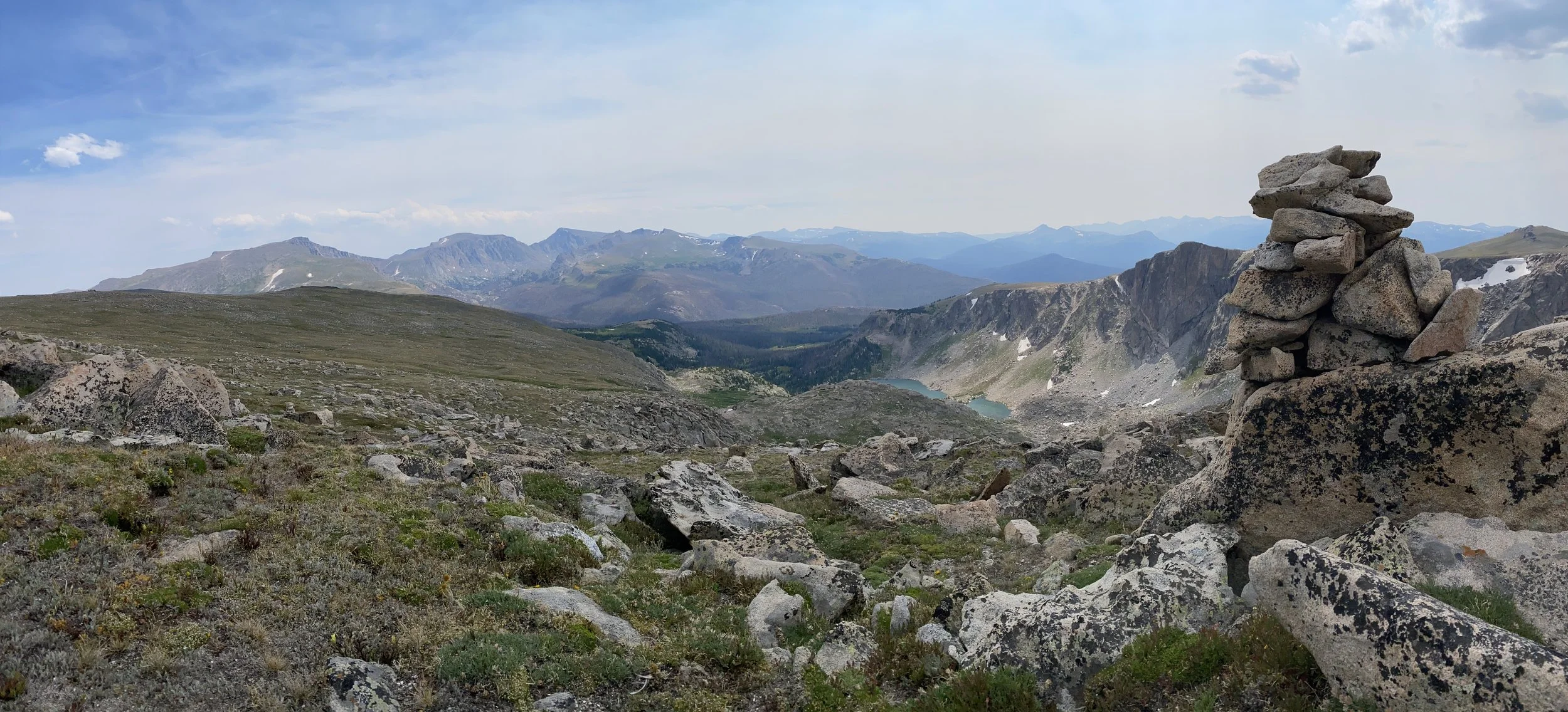
The original route I planned when working on this project linked a series of trails over Comanche Peak, but due to its lack of congruency with the overall route, I decided to use the lower Mummy Pass Trail as the Redline Route. The Comanche Peaks High Route alternate was published for those who didn’t mind going a little out of the way for the chance to experience the views from Comanche Peak. Thanks to hikers who provided valuable feedback on a section of this alternate, I discovered it required fording the Cache la Poudre River, which poses a challenge to anyone looking to ford it and may be dangerous to attempt in the early season. Due to this, I have removed the Comanche Peak High Route alternate.
The entire region around the Mummy Pass Trail (original Redline Route) saw massive destruction in 2020 from the Cameron Peak Fire, the largest fire in Colorado history. The Upper Mummy Pass Trail is nearly non-existent and is more of a route than a trail, not making it an optimal route through the area. After receiving similar feedback from hikers this season and having discussed the issue with Rocky Mountain National Park’s Wilderness Office, I have decided to remove the Upper Mummy Pass Trail as the Redline Route through the area.
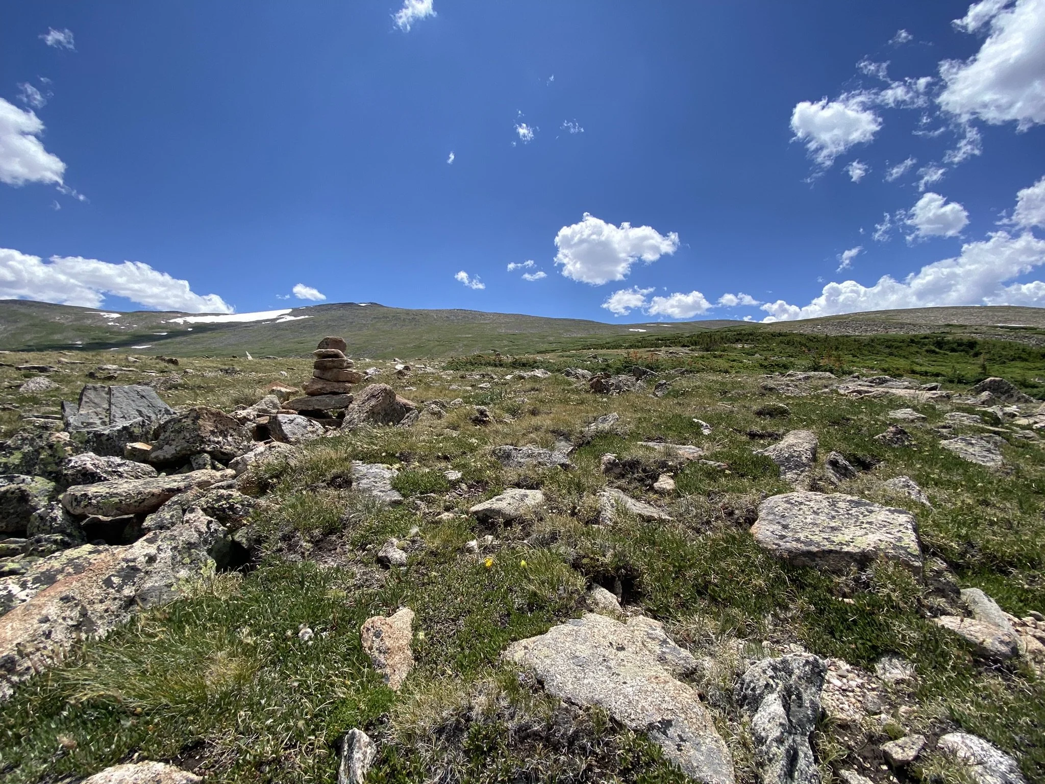
Having spent several weeks looking at possible alternatives both on paper and in the field, I believe there is an optimal route which travels over Comanche Peak, climbing over 12,500 feet in elevation. This reroute uses Forest Service Road 145, Bear Creek Trail, Hourglass Trail, Comanche Peak Trail, and Mirror Lake Trail before connecting to the Lower Mummy Pass Trail in Rocky Mountain National Park. Trail Guides, Maps, GPS Routes and GPS Waypoints have been updated to reflect this route change. This reroute is 4.4 miles longer, has 1,600 more feet of elevation gain and 1,500 more feet of elevation loss.
Though the Upper Mummy Pass Trail is in dire need of maintenance, the area around Mummy Pass is beautiful and provides a lower route option for those not interested in going over the high country. With this in mind, the Mummy Pass Alternate has been added, and it follows the previous Redline Route. This alternate requires route finding and spends significant time above treeline, not making it “safe” to use in stormy weather. Proper planning is required for any route chosen in this area.
The Rocky Mountain National Park Bypass still requires fording the Cache la Poudre River, which runs very high in the early season. The bridge, which use to reside at this crossing, was washed out many years ago. A rebuilding of this bridge would be a great project for the Northern Colorado Trail Community to support in the future. With dogs not being allowed in the national park, this bridge would provide a safe path for those looking to hike the route with their furry companion as well as provide a much lower alternate route through the area.
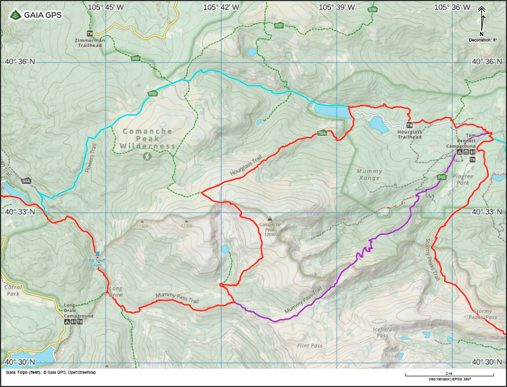
Map of changes to Segment 1 Redline Route - RMNP Bypass (Cyan) - Added Mummy Pass Alternate (Purple) (Previous Redline Route)
Segment 4 New Alternate Route - White River Bypass
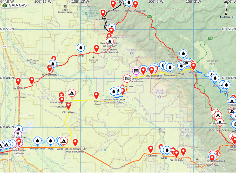
In the southern region of Segment 4, the Northern Colorado Trail route requires fording the White River. Most of the season, this is a simple task requiring basic knowledge about river crossing. The White River is shallow enough in places to enjoy a refreshing swim and often has people fishing while wading in the river. That being said, the river does run higher in the early season before the snow has fully melted, and during high snow years this may continue later into the hiking season.
With this in mind, the White River Bypass has been added (Trail Guides, Maps, GPS Route, GPS Waypoints) which avoids this river ford while still providing incredible scenery. This alternate is 6.9 miles shorter than the Redline Route and bypasses scenic points such as Wall Lake, Lost Solar Park, and the Nichols Creek Trail, which offers grand views during the descent to the White River.

Segment 4 - White River Bypass (Blue)
With the hiking season well underway and more hikers finding their way to the trails along the route, more route updates could happen, but are not expected. Check the Trail Alerts/Updates page for the most up to date information.
Within the next week, a route completion page will be added for anyone who feels they have completed all of the segments of the Northern Colorado Trail.

⚠️Trail Alert: Cache la Poudre River Ford
Cache la Poudre River - Big South Trail - Washed out bridge location - July 2, 2025
Who: For those planning on hiking the second half of the Rocky Mountain National Park Bypass (formerly the Mummy Pass Bypass) after passing the Tom Bennett Campground
or
For those planning on hiking the Comanche Peak Alternate (High Route).
Where: RMNP Bypass (formerly Mummy Pass Bypass) - Mile 27.7 (SOBO)
and
Comanche Peak Alternate (High Route) - Mile 11.3 (SOBO)
Where the Flowers Trail (#939) and the Big South Trail (#944) intersect, hikers are required to ford the Cache la Poudre River.
What: It was originally published on the Northern Colorado Trail Guides that there was a bridge to to cross the Cache la Poudre River. It turns out this bridge was washed out years ago and was never rebuilt. The river runs quite high throughout the season from seasonal runoff to the flow control from the Long Draw Reservoir. This poses a serious risk to backpackers hiking these routes. This is a major river ford and should not be underestimated.
Major NOCO Trail Updates: Route Changes, Waypoints & More!
Big Updates for the NOCO Trail! We've made key improvements to the Northern Colorado Trail, including reroutes to avoid private land, a new redline into Walden, over 1,000 waypoints added, and refinements to the trail guides and maps. These changes enhance navigation, improve trail flow, and ensure a fully publicly accessible route. Read the full update to see what’s new and how it impacts your hike!
Over the past few weeks, I’ve made some major updates to the Northern Colorado Trail (NOCO Trail) based on feedback, field reports, and careful route analysis. These changes improve the trail's viability, eliminate private land crossings, refine the redline route for better flow, and add detailed waypoint data to the trail guides and maps. Here’s a breakdown of what’s new and why these changes were made.
Private Land Adjustments & Mendenhall Route Becomes the Redline into Walden
Two sections of the previous route crossed private land:
Near Walden (where the trail crossed the Canadian River).
Near Highway 131 (approaching Yampa).
While these were the most efficient and scenic routes, they required trespassing or landowner permission—neither of which is a sustainable option for an official long-distance trail. As a result, the NOCO Trail has been rerouted to avoid private property entirely.
Near Walden, the official redline now follows the Mendenhall Trail into town. This was previously an alternate route, but it now serves as the primary route for the NOCO Trail.
The Jack Dickens Alternate (Orange) remains a viable option for hikers who prefer a shorter approach into town. However, it involves more road walking and skips the Medicine Bow ridgeline, which offers some of the best views on the entire route.
Near Yampa, the route now sticks to public forest roads, leading to a short road walk along Highway 131 into town.
This ensures that NOCO Trail hikers have a fully public and legal route, while still maintaining a high-quality backcountry experience.
Medenhall Trail Alternate (New Redline), Jack Dickens Alternate (Orange), Ute Pass Bailout (Yellow - previous Redline)

Forest Road 285 - County Road 6 - Highway 131 (previously the Eagle Rock Bypass)
Lower Route After Mummy Creek Pass
Previously, the redline followed the Comanche Peak High Route, which offered incredible views but also came with challenges. The new lower route was chosen because:
It flows better with the overall direction of the NOCO Trail.
It avoids exposure to storms above treeline, making it a safer and more consistent option.
It offers more camping opportunities and water access.
That said, the Comanche Peak High Route remains a fantastic alternate for those looking for a scenic ridge walk. While the Cameron Peak Fire burn scar remains a dominant feature along this section, it still offers stunning views and a unique look at the landscape’s recovery.

Mummy Pass Trail + Big South Trail (New Redline), Comanche Peak High Route (Purple), Mummy Pass Bypass (Cyan)
Rerouting South of Highway 40 (Segment 3)
A significant update was made to the section just south of Highway 40, near Rabbit Ears Pass:
Previously, the NOCO Trail followed Forest Road 100 straight to the Silver Creek Trail.
Based on a recommendation from a Volunteer at the Friends of Wilderness (FOW), the new route now follows:
Forest Road 251 → Forest Road 303 → Routt Divide Trail, before reconnecting with Forest Road 100 and the Silver Creek Trail.
This adjustment improves trail flow and makes the transition between segments more natural. It also keeps the route in alignment with existing hiking infrastructure rather than relying too heavily on forest roads.

Forest Road 251/303 - Routt Divide Trail (New Redline), Routt Divide Bypass (Cyan)
More Than 1,000 Waypoints Added!
A major upgrade to NOCO Trail data: detailed GPS waypoints have now been integrated into the trail guides and maps. These waypoints provide key location-based info, including:
Trail intersections (with names and markers matching on-trail signage).
Water sources (including seasonal flow estimates).
Campsites (with estimated capacity and shelter information).
Trailheads & parking areas (noting vehicle accessibility).
Town Service Waypoints (for resupply and town information).
Scenic viewpoints and other points of interest.
To ensure consistency and accuracy, waypoint names in the guide match those in the GPS files and printed maps. This allows hikers to easily reference the same landmarks across different planning tools.
Datasheet Updates & Edit Logs
While revising the trail guides, I caught a few minor mileage errors and clarity issues. These weren’t major, but to keep things transparent, each datasheet now includes an edit log at the bottom. This log:
Documents all version changes (date + specific edits).
Ensures hikers can always verify they have the latest version by checking the date in the PDF header.
This should make it easier to track updates and avoid confusion over past versions of the route.
Growing Excitement & Community Engagement
The response to the NOCO Trail has been incredible so far. While I won’t name specific groups yet, there has been enthusiasm from:
Local land management agencies.
Regional trail organizations.
The Continental Divide Trail (CDT) community.
People are excited to see the trail develop, and I look forward to hearing feedback from thru-hikers, section hikers, and day hikers as more people get out there this season!
Land Access Challenges in Walden & Yampa
The remaining private land issues near Walden and Yampa are mostly related to ranching and recreation conflicts. These sections already have roads and trails, but they pass through private property with posted no-trespassing signs.
While these detours are manageable, the ideal long-term goal is to find a mutually beneficial solution that allows the trail to follow a scenic, optimized route through these areas. This could involve:
Building community relationships with landowners and town officials.
Exploring conservation easements or agreements to allow passage.
Potentially developing a dedicated hiking corridor in the future.
The goal isn’t just trail access—it’s about finding a way for the NOCO Trail to positively contribute to the communities it passes through. These conversations are ongoing, and I’ll provide updates as they develop.
A Huge Thank You to the NOCO Trail Community
This project wouldn’t be possible without your support. Whether you’ve donated, shared information, or just followed along, you’re helping to build something truly special.
This latest round of updates solidifies the NOCO Trail as a fully publicly accessible route, while improving navigation, data accuracy, and overall hiker experience. There’s still more work to be done—particularly with landowner outreach—but the trail is better than ever heading into the 2025 hiking season.
I’d love to hear from hikers heading out this year—Join the Northern Colorado Trail Facebook Community
With these changes the Official Length of the Northern Colorado Trail stands at 299.8 Miles.
Thank you, and happy trails!
The Northern Colorado Trail Now Officially Online!
Announcing the official launch of the Northern Colorado Trail Website.

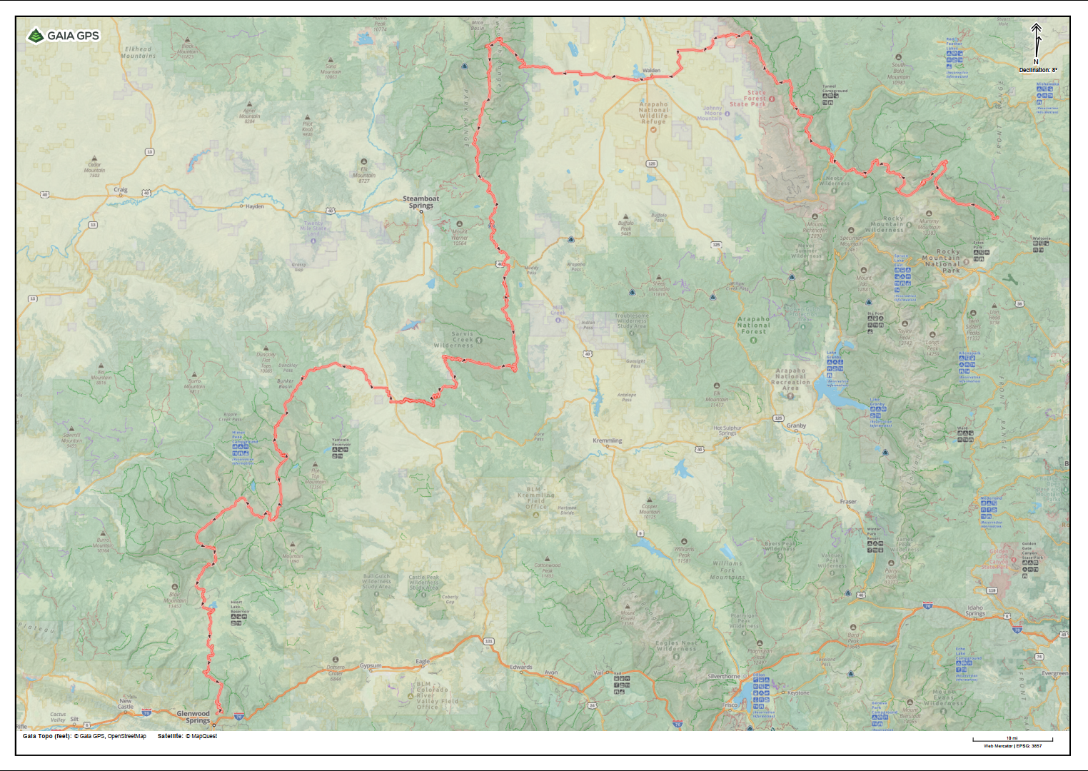
Map of the Northern Colorado Trail, highlighted in red, showing the 292-mile route along the GaialGPS topo maps, from Estes Park to Glenwood Springs.
We're excited to announce that the Northern Colorado Trail is now officially online! After months of hard work, we’re thrilled to provide hikers, backpackers, and adventurers with a dedicated website packed with essential resources.
Explore the New Website
The website features trail guides, interactive maps, downloadable GPS files, and much more to help you plan your journey along the 292-mile trail that stretches from Estes Park to Glenwood Springs. Whether you're a seasoned thru-hiker or someone planning your first adventure, our goal is to make it easier for you to access the information you need to safely navigate the trail.
What’s Included:
Trail Guides: Detailed data sheets with waypoint information, distances, elevations, and more for each trail segment.
Maps: Downloadable PDFs and interactive maps to help you plan and navigate your route.
GPS Files: GPX, KML, and GeoJSON files for seamless navigation on your GPS device or mapping software.
Live Updates: Stay informed with important alerts and updates about the trail, conditions, and resources.
Get Ready for the 2025 Backpacking Season
With the 2025 backpacking season just around the corner, the Northern Colorado Trail is now ready for explorers to discover its beauty and challenge. We’re here to support your adventure with all the tools and information you need to safely and confidently trek through Northern Colorado’s stunning landscapes.
Stay tuned for future updates, and if you have any questions or need more information, don’t hesitate to contact us!